 Leave the mapping to us! Senate has been providing Geographic Information System (GIS) services for over sixteen years. We currently provide GIS services to over forty municipalities, as well as, private clients. Our services cover all aspects of GIS development from needs assessment to data creation and on-site training. Our experience has allowed us to establish strong working relationships with state and county governments, as well as other public sources of GIS data.
Senate has been successful in assisting municipalities in acquisition of funding for GIS projects. Senate provided assistance to our clients in their application for an ESRI Local Government Assistance Grants.
Our main focus in serving local governments has been towards the development and maintenance of municipal GIS systems. We are actively involved in all phases of GIS development from needs assessment and data development to on-site training and mobile GIS once the system is completed. Examples of coverages that we have created include:
 – Base mapping layers – Tax Parcels – Roads – Soil Analysis
– Sanitary Sewer Systems – Railroads – Water Systems – Land Use
– Drainage – Zoning Districts – Steep Slopes – Lakes
– Building footprints – Fire hydrants – Utilities – Floodplains
– Contour lines – Storm Sewer Systems
Senate offers GPS Rental Services!
Senate is pleased to announce the introduction of GPS rental services from our GIS Department. We offer (1) 2008 Trimble GeoXH sub-foot, mapping grade GPS unit for your GIS mapping needs.
This unit is ideal for municipalities, boroughs and authorites in need of data collection, inventory and asset managment (i.e. GASB-34) for such structures as:
- Storm and sanitary items (inlets, manholes, pipes)
- Traffic facilities (stop signs, signals, public signs, bridge and road maintenance schedules)
- Water/Wastewater facilities (hydrants, valves, pump stations)
- Recreational facilities (park boundaries, tree shade programs, trails)
Digital data collection forms can be customized to collect information about any structure, including monitoring: condition, age, year built, date repaired, date replaced, ID number, current monetary value, depreciation, road intersections, material, etc.
We offer weekly and monthly rental rates, on-site training, as well as, all accessories needed for data collection (external antenna, cables, etc).
Please contact Chris Urik in our GIS Department for more information or to schedule a demonstration.
 Among the many GIS Services we offer:
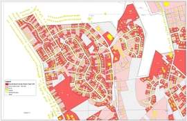
Cadastral Mapping: a map showing boundaries and ownership of land (such details as Survey District Names, positions of existing older structures, lot and block numbers and adjacent street names).
Base Mapping: maps of geographic features such as country boundaries, rivers, roads, railroads, and airports, etc
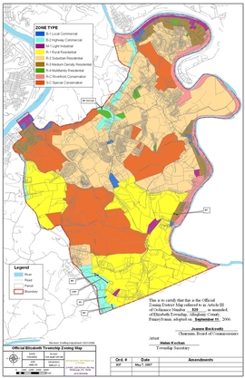
Zoning Map preparation (Residential, commercial, etc)
Road Maps for 911 readdressing
Parcel Map generation from As-built or CAD drawings
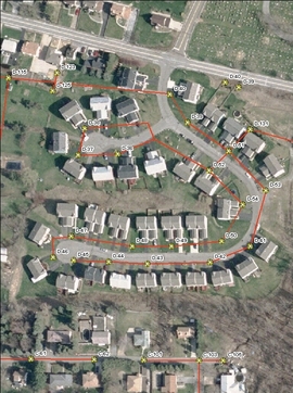
Sanitary Sewer Map preparation created from As-built or CAD drawings detailing sewer structures and attributes (manholes – depths, inverts, pipes – material, size)
Complete Sanitary and Sewer System GPS’ing with attributes
Storm Sewer Mapping created from As-built or CAD drawings detailing (catch basins, outfalls, headwalls, and pipes)
Paving Programs for Municipalities
Map Books
MS4 Stormwater Protocol Compliance
Permit Tracking Applications
Funding Source Identification
Grant Application Assistance
Database Design/Importation